


Yet the new app, called the LandsMap app (available on Google Play and Apple’s App Store), does so much more. It marks a new chapter in transparency for a local government office that for decades has profited from having such information in its secluded possession.
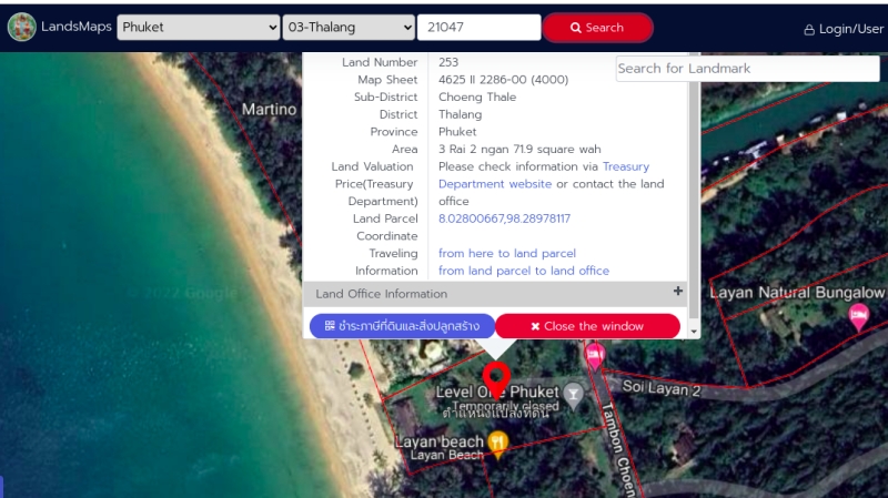
What the new app shows is the land title deed number issued for every plot in Phuket registered with the Lands Department. The map uses Google Maps as a base. People can double-click on any parcel marked on the map and see the title deed number and the current registered valuation of the land.
The registered land valuation is the reason for the creation of the interactive map, Mr Nisit explained on Friday, signalling that the government is preparing to make good on its promise to crack down on collecting land taxes as a form of generating revenue for the state coffers, which has become a high priority for the economy.
The new app has already proved popular, with more than 500,000 downloads from Google Play alone. The map also has a web interface, found here: https://landsmaps.dol.go.th/
Yet it is what the map doesn’t show that will be very useful. The areas where there has never been a land title deed issued are not marked off in red.
One such example is the illegal excavation of a hill just north of the bypass road that is now under investigation. The map plainly shows no deeds ever issued for the area being excavated (see image above). That one fact should help investigators greatly in the claims made by the man saying he has a title deed for the plot, a land title deed that is now also under investigation.
The map, as expected, may not be fully up to date and will include plots marked that need further investigation. A quick check revealed that a plot on the Layan beachfront that had its land title deed investigated and found to be illegal in 2017 was still marked on the map. In that case the “owner” of the land and officials were all found guilty of being involved in illegally issuing the land title deed, which was later sold on to another person for B330mn.
A simple reason for such parcels still being marked as plots is that when such titles are found to be illegal standard practice is to just transfer “ownership” of the parcel to the Treasury Department, which is the standard “holder” of titles to all state land. Hence, due care is urged when viewers try to understand what information the map is actually presenting to them.
The map, regardless of its shortcomings, marks a great leap forward for a government department in making what is supposed to be public information actually openly accessible to the public ‒ and that, in this country, is to be highly praised.